|
Nubia is located in today's southern Egypt and northern Sudan.
This land has one of the harshest climates in the world. The temperatures
are high throughout most of the year, and rainfall is infrequent.
The banks of the Nile are narrow in much of Nubia, making farming
difficult. Yet, in antiquity, Nubia was a land of great natural
wealth, of gold mines, ebony, ivory and incense which was always
prized by her neighbors.
Nubia is the homeland of Africa's earliest black culture with
a history which can be traced from 3100 B.C. onward through Nubian
monuments and artifacts, as well as written records from Egypt
and Rome.
|
 |
 |
To the ancient Mediterranean world, the land south of Egypt was
a territory of mystery and legend. Wealth and exotic products
came from there. It was the home of the Ethiopians, whom Homer
called blameless and stories about its great achievements endured
to tantalize the modern world. This land, which now includes Nubia,
is a land of enormous distances, and its exploration was long
impeded by problems of transport and political unrest.
In the last hundred years, Nubia has slowly yielded its secrets,
its vanished peoples, abandoned cities and lost kingdoms brought
to light by the excavator and copyist of inscriptions.
This exhibit is a selection of objects recovered over twenty years
ago by the Oriental Institute Nubian Expedition in the effort
to rescue archaeology from the rising water behind the Aswan Dam.
The land of Nubia is a desert divided by the river Nile. For want
of water and rich soil, most of Nubia has never been able to support
a large population for long periods. However, some of Africa's
greatest civilizations emerged here, centers of achievement whose
existence was based on industry and trade, Because they did not
write their own languages until very late in ancient times, we
know these centers and their people largely through their archaeology
and what the Egyptians and Greeks said about them.
|
|
 |
• A-Group: 3800-3100 B.C.
• C-Group: 2300-1550 B.C.
• Kerma Culture: 2000-1559 B.C.
• Egyptian Domination: 1950-1100 B.C.
• Napatan Period 747-200 B.C.
• Meroitic Period 200 B.C.-A.D. 300
• X-Group (Ballana Period) A.D. 250-550
• Christian Period: A.D. 550-1400
(All dates are approximate)
|
 |
 |
The earliest of the Nubian cultures (the A-Group and C-Group)
were located in northern Nubia.
Until recently it was thought that A-Group people were semi-nomadic
herdsmen. However, new research suggests that a line of kings
1ived in Qustul in northern Nubia as early as, or perhaps even
earlier than, the first pharaohs of Egypt.
The people of these early cultures buried their dead in stone-lined
pit graves, accompanied by pottery and cosmetic articles.
At this time, Nubia was known to the Egyptians as "Ta Sety,"
the "Land of the Bow," because of the fame of Nubian
archers.
|
 |
By 1550 B.C. kings at Kerma were ruling Nubia. They were buried
in huge round tombs, accompanied by hundreds of sacrificed retainers.
People of the Kerma culture were accomplished metal workers, and
they also made thin-walled pottery on a wheel. This was a time
of increased contact between Egypt and "Kush," as Nubia was then
called. Egypt dominated parts of Nubia from about 1950 to 1000
B.C. Forts, trading posts and Egyptian style temples were built
in Kush, and the Nubian elite adopted the worship of Egyptian
gods and even the Egyptian hieroglyphic writing system. The gold,
ebony and ivory of Nubia contributed to the material wealth of
Egypt, and many of the famed treasures of the Egyptian kings were
made of products from Nubia.
|
By 800 B.C., Egypt had fragmented into rival
states. In 747 B.C., the city of Thebes in southern Egypt was
threatened by northerners, and the Egyptians called upon the Nubian
king for protection. The Kushite king, Piye, marched north from
his capital at Napata, rescued Thebes and reunified Egypt. For
the next 100 years, Kushite kings ruled both Nubia and Egypt.
This era was brought to a close by the invasion of Assyrian armies
in 663 B.C., and the Nubian king fled south to his capital at
Napata
|
 |
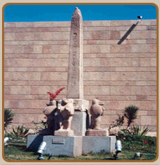
By 200 B.C., the capital had shifted yet farther
south to Meroe, where the kings continued to be buried in pyramid
tombs and to build temples to Nubian and Egyptian gods in a hybrid
Egyptian Roman-African style. Roman historians record the skirmishes
and treaties which marked the relation ship of Roman Egypt and
Nubia. By A.D. 250 the culture of Nubia changed radically, perhaps
due to the immigration of new peoples into the Nile Valley.
Pyramid tombs were replaced by the great tumulus burials of the
kings of Ballana. These kings were laid to rest with sacrificed
retainers, horses, camels, and donkeys. In the 7th century, Nubia
was converted to Christianity. The skill of Nubian archers forestalled
the conversion of Nubia to Islam until A.D. 1400.
|
 |
In the 1960's, a dam was constructed at Aswan,
Egypt. It created a 300-mile-long lake which permanently flooded
ancient temples and tombs were well as hundreds of modern villages
in Nubia. While the dam was under construction, hundreds of archaeologists
worked in Egypt and Sudan to excavate as many ancient sites as
possible. The Oriental Institute worked in Nubia from 1960 68.
Today, the 5000 Nubian objects in the collection of The Oriental
Institute Museum and thousands of objects in other museums are
our sole resource for recovering the rich civilization of northern
Nubia, for the sites themselves are lie beneath the waters of
Lake Nasser. In contrast, expeditions from many countries are
working in southern Nubia.
The modern inhabitants of southern Egypt and Sudan still refer
to themselves as Nubians. They speak the Nubian language as well
as Arabic. Thousands of Nubians from the north were forced to
relocate from their endangered homelands to be resettled in Egypt
and Sudan.
|
 |
 |
Precious Metals and Stones:
Egyptian interests in Nubia were always driven by economics.
The one factor that chiefly characterized Egypt's relationship
with Nubia through most of their history was exploitation.
Nubia's most important resource for Egypt was precious metal,
including gold and electrum.
The gold mines of Nubia were located in certain valleys and mountains
on either side of the Nile River, although the most important
mining center was located in the Wadi Allaqi.
That valley extended eastward into the mountains near Qubban (about
107 km. south of Elephantine).
Nubia was also an important source of valuable hard stone and
copper, both of which were necessary for Egypt's monumental building
projects.
|
 |
Trading in African Goods:
Especially important for Egypt was that Nubia was also a corridor
to central Africa and a point for the trans-shipment of exotic
goods from that region, including: frankincense, myrrh, "green
gold," ivory, ebony and other exotic woods, precious oils, resins
and gums, panther and leopard skins, monkeys, dogs, giraffes,
ostrich feathers and eggs, as well as pygmies (who became important
to Egyptian religious rituals). In the Old Kingdom, the Egyptians
regularly penetrated as far as the Second Cataract to barter for
these products which were coming down through the upper Nile Valley
(viz., the expeditions of Harkhuf, Hekayib, Mekhu and Sabni).
|
 |
Manpower:
Nubia was also an important source of manpower and labor for the
Egyptians. The Palermo Stone records that early in the Fourth
Dynasty, King Snefru led a military campaign into Nubia reputedly
to crush a "revolt" there (the Egyptians considered all enemies--whether
foreign or domestic--as "rebels" against the natural order).
According to that text, he captured 200,000 head of cattle and
7,000 prisoners, all of whom were deported to Egypt as laborers
on royal building projects. While some archaeologists argue that
this campaign was limited to Lower Nubia, others note that the
amount of 7,000 is rather high for a country that was fairly depopulated
at the time.
If the number was not inflated as royal propaganda, then Snefru
could have penetrated into Upper Nubia as far as the Land of Yam
and made his conquests there.
|
 |
 |
Egyptian Activities:
By the Old Kingdom (if not earlier in the Second Dynasty), the
Egyptians founded a settlement at Buhen which apparently was an
important site for copper production. Later, Khufu opened diorite
quarries to the west of Toshka and south of Buhen, while other
quarrying expeditions were sent south above the Second Cataract.
The Fourth Dynasty also saw the establishment of a regular messenger
service between the First and Second Cataracts.
By the reign of Sahure in the early Fifth Dynasty, the Egyptians
began trading with the Land of Punt, which was accessible only
by sailing along the seacoast on the Red Sea. Expeditions to Punt
began by sailing upriver to Coptos, then caravanning eastward
through the Wadi Hammamat or the Wadi Gasus to the seacoast.
There the expeditions built ships and embarked on the sea voyage
south. While the Egyptians did not penetrate Punt eastward from
the Nile in Upper Nubia, apparently some Puntite goods and pygmies
were trans-shipped to Egypt via a circuitous overland route through
Nubia.
|
Despite that Buhen was abandoned in the Fifth Dynasty and the
diorite quarries near Toshka were closed, Egypt maintained its
hold over Nubia in the late Old Kingdom.
In the early Sixth Dynasty, Egyptians were recruiting Nubian mercenaries
into the Egyptian army.
Weni recounts that he included five different Nubian peoples when
he assembled the great army of King Pepi I for the military campaign
to Canaan.
He also led a major quarrying expedition to Ibhat southeast of
the Second Cataract, and he built giant barges in Wawat, for which,
he says, the rulers of Wawat, Irtjet, Yam and Medja "dragged wood"
(in token humiliation?).
Later he cut a series of channels through the First Cataract,
after which King Merenre traveled to Elephantine in order to receive
the homage of the Nubian leaders. Pepi II prepared an expedition
to sail to punt in his reign, although it is uncertain that its
preparations were completed.
|
 |
Apparently, the governors of Elephantine at this time were responsible
for royal affairs in Nubia. Harkhuf recounts four successive expeditions
on which he served or directed to Upper Nubia and Yam in the reigns
of Merenre and Pepi II. He was a pathfinder, and his orders were
to discover routes through the country and to trade with its leaders.
While his earlier trips saw him traveling through Irtjet and Zatju
along the river, in his later journeys, these territories had
turned hostile to Egypt, forcing him to travel on desert tracts
and through the western oases. On his return to Egypt, laden with
goods, Harkhuf could only travel through Irtjet, Zatju, and Wawat
with the added protection of forces of the friendly ruler of Yam.
The change in the disposition of these territories was probably
spurred by the arrival of a new people who gradually overtook
Upper and Lower Nubia at this time and settled those areas. These
were the C-Group people who were hostile to Egypt, and ultimately,
they may have conspired to force Egypt out of Nubia at the end
of the Old Kingdom, when the Egyptian state began to fragment
and fall into civil war.
|
Nubian Confederacy:
Evidence indicates (e.g., the account of Harkhuf) that at certain
periods in the reigns of Merenre and Pepi II, the Upper Nubian
chiefdoms of Irtjett and Zatju, as well as Wawat in Lower Nubia,
united together under a single ruler. At some point, this C-Group
union might even have included the Early Kerma culture, which
was distantly related to the C-Group. Evidently, Yam stayed independent
of this confederacy. The purpose of the union, undoubtedly, was
to resist Egyptian penetration and colonization of Nubia. For
that reason, the Egyptians led by Hekayib, Governor of Elephantine,
launched a military campaign to suppress the C-Group, splitting
Wawat from the confederacy and helping to stabilize Egyptian control
of the region. However, the Egyptians were not able to pacify
Nubia entirely, despite several military campaigns in the Sixth
Dynasty. Nubia remained restive for the remainder of the Old Kingdom.
So, e.g., Sabni, Governor of Elephantine, recounts that he had
to journey quickly to Wawat with an army to recover the body of
his father, the previous governor, who had been killed on a trading
mission.
|
 |
| |
|
 |
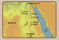
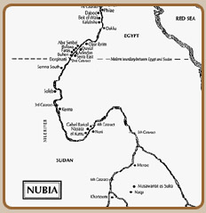
Geographical Limits:
The land of ancient Nubia was bounded on the north by the First
Cataract of the Nile River-- located just south of Elephantine--and
on the far south by the Sixth Cataract--located north of modern
Khartum. In certain periods, Nubia consisted of various ethnic
tribal groups or chiefdoms, while in other periods, it was governed
by larger and more politically complex kingdoms. Nubia was the
country that bordered ancient Egypt on the south and through much
of its history was politically dominated by the Egyptian state.
However, in those periods from the First Dynasty onward (ca. 3050
BC), whenever Egypt was unable to maintain her presence in Nubia
(e.g., because of her own internal difficulties), the various
Nubian cultures flourished and enjoyed their political and economic
independence, often formulating kingdoms of great dynamism that
were competitive with the Egyptian state.
|
 |
Political Frontiers:
In the Middle Kingdom, Egypt's southernmost border was fixed at
Semna, located south of the Second Cataract in an area of narrow
gorges and rocky outcroppings, known in Arabic as the Batn el-
Hajjar, the "Belly of Stones" (about 68 km. south of the modern
Egyptian-Sudanese border). Later in the New Kingdom, Egypt extended
her southern border up to the Fourth Cataract, although she exercised
military authority further upriver, as far as modern Kurgus (south
of Abu Hamed). The traditional ancient Egyptian name for Nubia
was Ta- Seti, "Land of the Bow" (as in "bow and arrow"). Indeed,
the Egyptians gave that same name to their southernmost nome which
bordered on Nubia, either because it was adjacent to that country,
or else because that portion of southern Upper Egypt was originally
part of an earlier kingdom of Nubia with the same name, and which
would have existed before the unification of Egypt.
|
 |
The Divisions of Nubia
For purposes of understanding history and geography,
Nubia is divided into two great regions, Lower Nubia and Upper
Nubia . Lower Nubia is the northern region extending nearly 400
km. from the First Cataract to the area around Semna and the Second
Cataract. Today, it corresponds to the area of southern Egypt
and the northern Sudan . Upper Nubia , which is south of Lower
Nubia , extends upriver along the Nile to the Sixth Cataract and
Khartum. It corresponds to what is today the central Sudan . The
Nile River , flowing through this region, is often termed, the
Middle Nile.
|
The Nile flows from south to north, i.e. from
the Ethiopian Highlands and modern Uganda to the Mediterranean
Sea. However, the geography of Upper Nubia is dominated by a giant
bend of the river between the Fifth and Fourth Cataracts, in which
the Nile actually turns to the southwest for about 270 km. before
turning northward again in its passage to the sea. The area where
it flows northward out of the bend and through to the Third Cataract
is called the Dongola Reach, named after the Sudanese town of
Dongola which dominates this part of the river. The great bend
itself can be called the Dongola-Abu Hamed Bend of the Nile. This
area, in which the water might be thought of as reversing direction,
was highly treacherous to ancient navigation because of the speed
of the rushing river here and the many rocky protrusions extending
for kilometers along the river bed; hence, this can be characterized
as an area of often intense white water.
|
 |
Nomenclature
Archaeological Names vs. Political Names:
In the study of Nubian history and archaeology, specialists use
two kinds of names to refer to the various ancient people and
cultures they encounter; these are political names and archaeological
names. Political names derive from ancient texts, and they reflect
the actual names that the Egyptians, Greeks, or Nubians themselves
gave to certain parts of Nubia or to the different Nubian peoples.
Archaeological names are those names given to particular cultures
or industries which are detectable by archaeology but for which
there are no associated ancient names; thus, there is no way to
know what names the people of these cultures gave themselves.
Here the archaeologists provide these cultures with either arbitrary
(and artificial) designations , e.g.: "A-Group, B-Group" and "X-Group,"
or they name them according to the archaeological sites in which
they were first discovered or which became their main centers,
e.g.: "Kerma Culture" (referring to the succession of Nubian cultures
found at the city of Kerma). Sometimes, the archaeological and
arbitrary designations are mixed, e.g., the X-Group can also be
referred to as the "Ballana Culture," since a main site for this
culture is the cemetery of Ballana. Rarely, a political/textual
name might combine with an archaeological designation, e.g., Nubadae-people
can now be identified with the X-Group. Similarly, it has been
suggested (justifiably or not) that the C-Group might be those
people which the Egyptians named the Tjemehu (i.e., Libyans of
the central Sahara).
|
Egyptian Names of Nubia:
All of the lands south and southeast of Egypt (sometimes also
including the northeast) the Egyptians called, Ta-netjer, "God's
Land." Within this great region, the Egyptians located the different
countries and people of Nubia. From the Old Kingdom onward, in
addition to Ta-Seti, the Egyptians applied the name Ta- Nehesy
as a general designation for Nubia (n.b., nehesy means, "Nubian;"
Panehesy, "the Nubian" becomes a common personal name, developing
into the Biblical name, Phineas).
|
 |
At the same time,
Egyptians gave the name Wawat specifically to Lower Nubia. This
name derived from one of several Nubian chiefdoms which were located
in this region during the late Old Kingdom. A generic designation
of the desert nomads of Nubia was the term Iuntiu or Iuntiu-setiu,
"Nubian tribesmen (lit.'bowmen')." The names which the Egyptians
used to refer to the various parts of Nubia and its different
peoples usually changed depending upon the era and the particular
tribal group in a given area.
Elsewhere in the Old Kingdom, the names Irtjet, Zatju, and Kaau
were used of particular people and areas of the country. While,
previously, they were thought to be in Lower Nubia, David O'Connor
has recently made a strong case for locating them in Upper Nubia.
The Land of Yam, visited by Harkhuf, Governor of Elephantine,
in the late Sixth Dynasty, was apparently located around the Fifth
or Sixth Cataracts. The Land of Punt was a country located east
of Upper Nubia and bordering on the Red Sea (i.e., extending from
the highlands to the sea). Since the Old Kingdom, the Egyptians
often enjoyed a productive relationship with a Nubian tribal people
from the land of Medja, named the Medjay (called the "Pan-Grave
People" by archaeologists). As fierce warriors, they were
incorporated as mercenaries into the Egyptian army as early as
the Sixth Dynasty. Later in the New Kingdom, they were employed
as the police force in Egypt, and the word medjay became the ancient
Egyptian term for "policeman."
From the Middle Kingdom onward, the Egyptians regularly used the
name Kash to refer to the powerful independent kingdom based in
Upper Nubia, first at Kerma (until that was destroyed by the Egyptians
in the sixteenth century BC), thereafter at Napata , then Meroe
(pronounced "meroway"). Kash is identified as the Land
of Kush in the Holy Bible. Kush's political dependency was the
territory of Sha'at (in the region of the Isle of Sai). Other
names attested at this time (mostly in execration texts) are:
Iryshek, Tua, Imana'a, and Ruket. In the eastern mountains were
Awshek and Webet- sepat.
|
In the early Eighteenth Dynasty, the Egyptians
also used the name Khenet-hennefer to refer to Kush, especially
during the military campaigns of Ahmose and Tuthmosis I. It appears
as a general designation of the area of Upper Nubia between the
Second and Fourth Cataracts, and designates the region for which
the city of Kerma was the center or capital. The name Irem was
applied in the Eighteenth Dynasty to the people who apparently
lived in the southern reach of the Dongola Bend (i.e., the old
territory of Yam). Later in the dynasty, the name Karoy was applied
to the vicinity of Napata.
|
 |
In the Late Period and during the Kingdom of
Meroe, the name, Island of Meroe, was given to the triangular
stretch of land on the east bank of the Nile, south of the Fifth
Cataract. This section, dominated by the city of Meroe, was bordered
on the north by the Atbara River, on the west by the Nile, and
on the south by the Blue Nile. The Island of Meroe was the heartland
of Meroitic civilization and the political and cultural center
of the Kingdom of Meroe from ca. 590 BC to AD 300.
|
 |
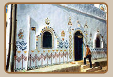
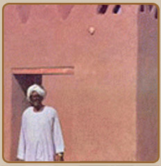
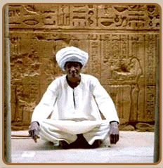
. The Nubians are believed to be the first human race on earth,
and most of their customs and traditions were adopted by the ancient
Egyptians.
. To the Greeks, they were known as Ethiopians and Nubia as the
land of Ponts, i.e; the land of gods.
. A Nubian has been always renowned for his sheer honesty. He
is an artist by nature and his lucky number all through is seven.
He holds the nine as a sacred object and wishes to stay on the
Nile bank throughout his life.
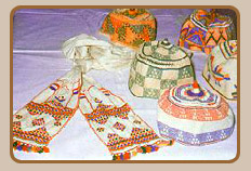
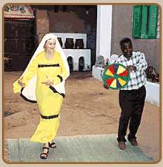
. A Nubian often prefers to marry, in the first place one of his
cousins. A Nubian wedding ceremony often lasts for 40 days, with
a long series of rituals. According to traditions, the groom has
to present several gifts, particularly garments for the bride,
her mother and sisters.
. These presents are boarded on a camel, adorned with decorations
colorful silk fabrics and jewelry. During the wedding ceremony
the groom is well-dressed, holding a sword and a whip.
. The social status of a Nubian is judged by the wealth of land
and waterwheels he owns, as well as his noble descent.
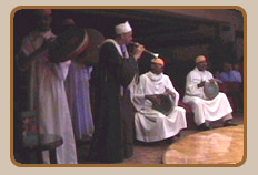
. Performance of prayers, for a Nubian, is evidence to his vividness
and an object of pride to his tribe. It is further evidence that
he is not a charlatan or a slave.
. A Nubian, who doesn't perform his prayers, is punishable by
public disdain and banishment away from the tribe.
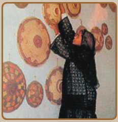
. A Nubian woman normally bears loads of jewelry, all over her
body. Around the neck, she carries 2 lines of necklaces, topped
by two lines of jewelry, bearing the Divine Name of Allah. On
the forehead, there is a piece of jewelry showing a Quranic verse,
with a large pair of earrings draggling from the top part of both
ears, a second pair from the lower part a third in between. The
ankle is adorned with a silver anklet and fingers with silver
rings.
. A Nubian woman adorns herself also with tattoo, normally shaped
like a mole on the cheek a crescent on the forehead or a line
drawn from the lip down to the chin or by coloring the nether
lip.
. The Nubian woman is known for her remarkable use of henna ad
perfumes.
|
|